Houston, Texas — Forecasters are closely monitoring a developing weather system in the Gulf that could strengthen into a tropical depression or tropical storm in the coming days, while already increasing the risk of dangerous flooding across large portions of the southern United States.
According to the latest forecast information, the disturbance known as Invest 90L has moved into the warm waters of the Gulf, creating conditions that could support tropical development. Meteorologists say the chances of the system becoming more organized have increased significantly, prompting heightened attention from weather agencies across the region.
While uncertainty remains regarding the storm’s future track and strength, experts warn that heavy rainfall and flash flooding could become the most serious threats for millions of people this week.
Tropical Development Chances Continue to Increase
The National Hurricane Center has raised the probability of tropical development to 50% over the next seven days, making Invest 90L one of the most closely watched weather systems currently affecting the region.
An “invest” designation is assigned to weather disturbances that forecasters believe have the potential to develop into tropical systems. The classification allows meteorologists to closely monitor environmental conditions and run specialized forecast models.
As Invest 90L moves through the Gulf, warm ocean temperatures and abundant moisture may help the system organize further.
Should development continue, tropical storm watches or alerts could eventually be issued for portions of the Gulf Coast.
Flooding May Become the Biggest Threat
Even if the system never reaches tropical storm status, forecasters emphasize that the flooding risk remains significant.
A combination of deep tropical moisture and a strong cold front moving southward is expected to create conditions favorable for repeated rounds of heavy rain.
Meteorologists warn that slow-moving thunderstorms could repeatedly track over the same areas, increasing the likelihood of flash flooding.
Some regions have already been placed under a Level 3 out of 4 flood threat, indicating a heightened risk for significant flooding impacts.
Weather experts say localized flooding could become severe in some communities, especially where heavy rainfall persists for multiple days.
Major Cities Could See Several Inches of Rain
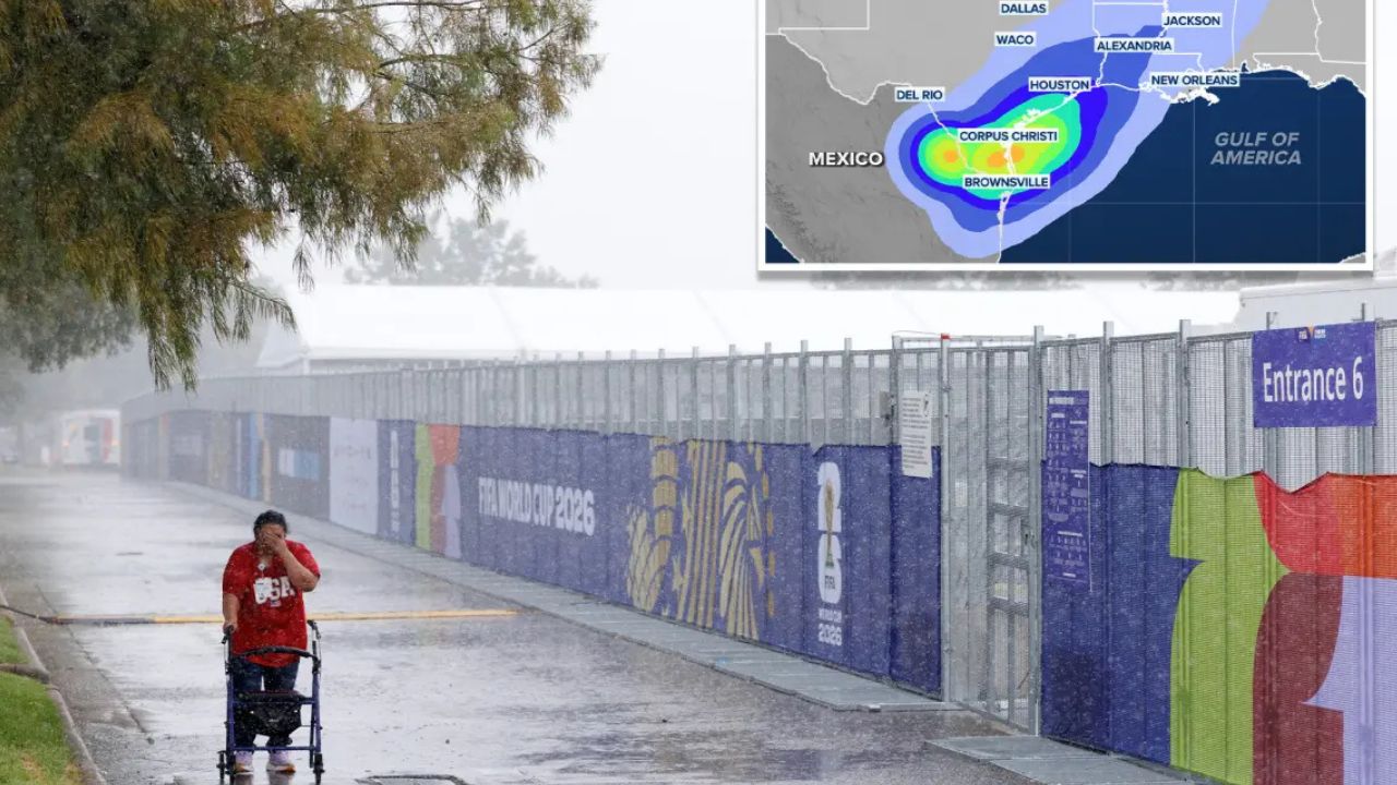
Several large metropolitan areas are expected to experience periods of intense rainfall throughout the week. Cities including Houston, Corpus Christi, and Jackson, Mississippi, are among the locations facing elevated flood concerns.
Forecast models suggest rainfall totals could reach 5 to 8 inches in some areas, with isolated locations potentially receiving even higher amounts where thunderstorms repeatedly develop.
Flood watches have already expanded across portions of the Gulf Coast as emergency officials encourage residents to stay informed about changing weather conditions.
Road flooding, rising creeks, and temporary travel disruptions are all possible if rainfall amounts exceed current projections.
Forecasters Monitoring Potential Tropical Storm Formation
The National Hurricane Center has designated part of the northwestern Gulf as an area of interest as meteorologists continue evaluating the system’s potential development.
At the same time, weather models remain somewhat divided regarding the exact path and timing of the disturbance.
Damaging Winds Up to 70 MPH and Possible Tornadoes Could Hit Chicago Region Wednesday
Some forecasts suggest the system could linger through much of the week, prolonging rainfall threats into Friday and possibly beyond.
Others indicate the circulation could shift southward later in the week, changing where the heaviest rain falls.
Regardless of whether the system receives an official tropical name, forecasters stress that residents should focus on the flood threat rather than the storm classification itself.
Residents Urged to Stay Weather Aware
Emergency management officials across the region are encouraging residents to monitor forecasts closely as conditions evolve.
Flash flooding can develop quickly, particularly in urban areas and locations that receive repeated rounds of rainfall.
With tropical moisture expected to remain in place through midweek, weather experts say preparedness and awareness will be critical for communities across the Gulf Coast and Deep South.
As forecasters continue tracking Invest 90L, millions of residents from Texas to Georgia will be watching closely to see whether the system develops further and how much rain ultimately falls across the region.
Do you live in an area under a flood watch or heavy rain threat this week? What preparations are you taking as the system moves across the Gulf Coast? Share your thoughts and experiences respectfully in the comments below.