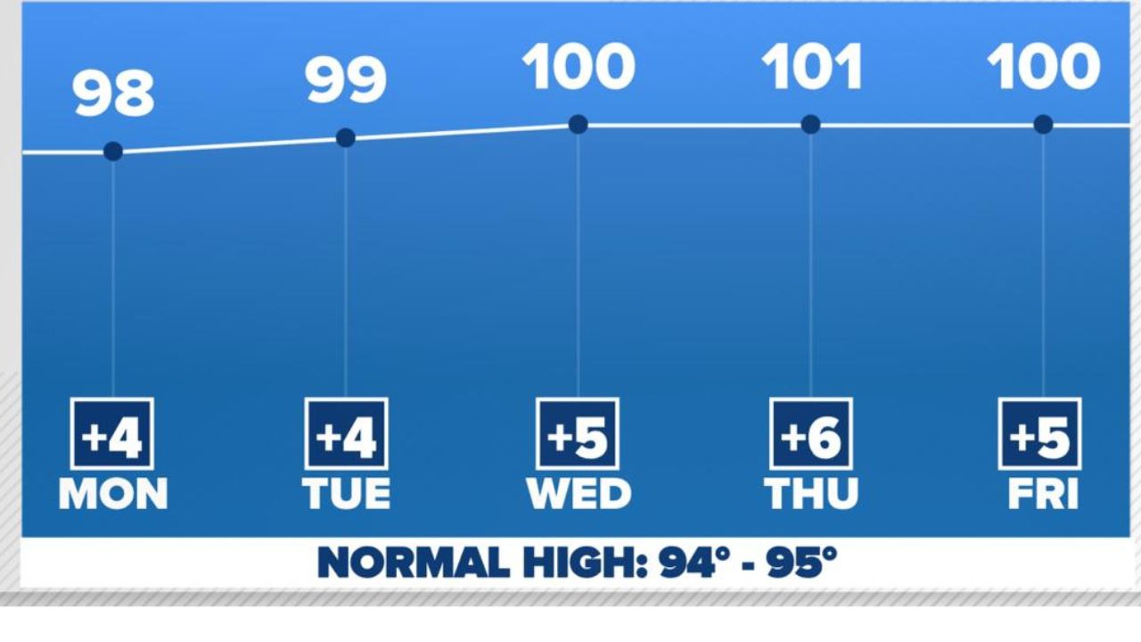
Dallas-Fort Worth, Texas — North Texas residents should prepare for a mix of isolated thunderstorms early in the week followed by the hottest temperatures of the summer so far, with the Dallas-Fort Worth area expected to reach the 100-degree mark for the first time this year.
While rain chances remain limited, the biggest weather story this week will be the return of dangerous summer heat as a strong ridge of high pressure settles over the region.
Isolated Storms Could Develop Monday and Tuesday
Forecasters say scattered showers and thunderstorms are possible across North Texas on both Monday and Tuesday, mainly during the afternoon and evening hours.
Most communities are expected to remain dry, but areas that do see storms could experience brief heavy rainfall, frequent lightning and gusty winds.
The storms are expected to develop as daytime heating increases instability before quickly weakening later in the evening.
No severe weather is currently expected, but weather conditions can change rapidly. Anyone planning to spend time outdoors should monitor local forecasts and be prepared to move indoors if thunderstorms develop nearby.
Despite the possibility of a few storms, forecasters say there is no need to cancel outdoor plans, as rainfall will be isolated rather than widespread.
DFW’s First 100-Degree Day Is Likely This Week
The more significant change arrives during the middle of the week as a strengthening ridge of high pressure builds across Texas, allowing temperatures to climb steadily.
High temperatures are expected to reach the upper 90s before likely hitting 100 degrees by Wednesday or Thursday, marking the first triple-digit day of the year for the Dallas-Fort Worth area.
Although North Texas has already experienced several stretches of hot weather this summer, DFW has not yet officially reached the 100-degree mark in 2026.
Typically, the area’s first 100-degree day occurs around July 1, meaning this year’s milestone is arriving only a few days later than average.
Heat Safety Becomes Increasingly Important
With temperatures expected to reach triple digits, residents are encouraged to take precautions to reduce the risk of heat-related illnesses.
Stay hydrated by drinking plenty of water, wear lightweight clothing whenever possible, and limit strenuous outdoor activities during the hottest part of the afternoon.
People working or exercising outside should take frequent breaks in shaded or air-conditioned areas, while checking on children, older adults and pets who are especially vulnerable during periods of extreme heat.
Even after sunset, warm overnight temperatures may provide little relief, making it important to stay cool whenever possible.
Belgian Waffle Favorite Expanding to Boston Common With New Café Near Emerson College
Hot Pattern Expected to Continue Into the Weekend
Looking ahead, forecasters say isolated thunderstorm chances may return next weekend, but the overall weather pattern is expected to remain dominated by above-average temperatures.
That means the heat isn’t going anywhere anytime soon, with North Texas likely to remain locked into a typical midsummer pattern featuring hot afternoons and only occasional pop-up storms.
Residents should continue monitoring the latest forecasts throughout the week, especially as temperatures climb toward the century mark and isolated thunderstorms remain possible.
How are you preparing for the first 100-degree temperatures of the summer? Do you have plans to stay cool this week? Share your tips and thoughts in the comments below.