Miami, Florida — Florida residents could see several days of soaking rain and localized flooding this week as deep tropical moisture spreads across the state, even though forecasters say there is no chance of the weather system developing into a tropical storm.
Meteorologists are closely monitoring a weak area of low pressure off the Southeast coast that, despite lacking tropical development potential, is expected to deliver repeated rounds of heavy rainfall across much of the Sunshine State.
Officials are urging residents to remain alert for changing weather conditions as thunderstorms increase through Wednesday.
Tropical Moisture, Not a Tropical Storm, Is the Main Concern
While the offshore disturbance is not expected to organize into a named tropical cyclone, it is still transporting abundant tropical moisture toward Florida.
Forecasters say the system will interact with a cold front pushing south across the state, creating favorable conditions for widespread showers and thunderstorms.
Rather than strong winds or storm surge, heavy rainfall is expected to be the primary hazard.
The combination of tropical humidity and the approaching front is likely to produce periods of intense downpours capable of overwhelming drainage systems in some communities.
Cold Front Expected to Trigger Repeated Thunderstorms
As the cold front moves across northern Florida, it will tap into the deep moisture already covering the peninsula.
That setup is expected to generate numerous thunderstorms from northern Florida into Central and South Florida.
Weather experts say the greatest concern is that the front will gradually slow before eventually stalling over portions of the state.
When that happens, thunderstorms may repeatedly move across the same locations, increasing rainfall totals over a short period.
This pattern raises the risk of localized flooding, particularly in cities where pavement and poor drainage allow water to accumulate quickly.
Southeast Florida Faces Greatest Flood Risk
Forecasters have placed portions of Southeast Florida under a Level 1 out of 4 risk for flash flooding through Wednesday.
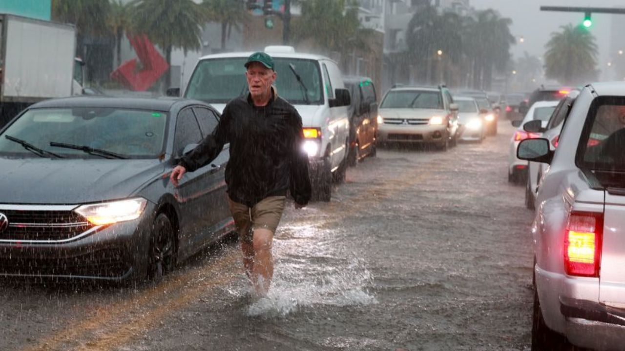
The threat includes the Miami metropolitan area, where repeated thunderstorms could produce localized urban flooding during periods of heavy rainfall.
Other cities, including Jacksonville and Tallahassee, are also expected to experience frequent showers and thunderstorms as the weather pattern unfolds.
Although widespread river flooding is not anticipated at this time, motorists could encounter flooded streets, reduced visibility, and hazardous travel conditions during the heaviest rain.
Residents in flood-prone neighborhoods are encouraged to closely monitor local forecasts and avoid driving through water-covered roadways.
Heat Dome Influencing Weather Pattern
Meteorologists say the broader weather setup is also being shaped by a large heat dome expanding across the eastern United States.
While that high-pressure system is fueling dangerous heat across parts of the Northeast, it is also helping steer the offshore disturbance back toward the west.
Heat Advisory Issued Across Pittsburgh Area as Near-100° Heat Index and High Humidity Arrive
That movement is allowing additional tropical moisture to flow into Florida, prolonging the period of unsettled weather.
Even though tropical cyclone formation is not expected, the moisture-rich atmosphere will continue supporting heavy rainfall and scattered thunderstorms through midweek.
Residents Urged to Stay Weather Aware
Forecasters emphasize that a low chance of tropical development does not mean low-impact weather.
Heavy rain can create dangerous conditions even without a named storm, particularly in urban areas where drainage systems can become overwhelmed in a short period.
Officials recommend monitoring weather alerts, allowing extra travel time during heavy rain, and avoiding flooded roadways if storms develop.
With additional rainfall expected over the coming days, residents across Florida are encouraged to remain prepared for rapidly changing weather conditions.
Has your area experienced flooding from heavy rain even without a tropical storm? What steps do you take to stay safe during flash flood events? Share your thoughts respectfully in the comments below.